Directory of Map Projections
 Cylindric
- БСАМ
- Карченко-Шабанова
- Урмаева III
- цилиндрическая Павлова
- Braun cylindric
- BSAM
- Cassini
- Cassini-Soldner
- central cylindric
- cylindric equal-area
- Balthasart
- Behrmann equal-area
- Craster rectangular equal-area
- cylindric equal-area
- Gall orthographic
- Gall-Peters
- Hobo-Dyer
- Lambert equal-area cylindric
- Peters
- Smyth equal-surface
- Tobler world in a square
- Trystan Edwards
- equidistant cylindric
- equirectangular
- Gall isographic
- Gall stereographic
- geographic projection
- Karchenko-Shabanova
- la carte parallélogrammatique
- lat⁄lon
- Marinus
- Mercator
- complex latitude plane
- ellipsoidal Mercator
- ellipsoidal oblique Mercator
- ellipsoidal transverse Mercator
- Gauss conformal
- Gauss Hannover
- Gauss-Krüger
- Gauss-Schreiber
- Hotine
- Mercator
- oblique cylindric orthomorphic
- rectified skew orthomorphic
- Thompson transverse Mercator
- transverse cylindric orthomorphic
- Universal Transverse Mercator
- UTM
- Wallis 1 transverse Mercator
- Wallis 2 transverse Mercator
- Web maps Mercator
- Wright
- Miller cylindric
- Patterson
- Pavlov cylindric
- perspective cylindric
- plane chart
- plate carrée
- rectangular
- simple cylindric
- simple perspective cylindric
- transverse plate carrée
- Urmayev III
 Pseudocylindric
- Apian II
- Apianus II
- Atlantis
- Babinet
- Boggs eumorphic
- Bomford modified Gall
- Bromley
- Cabot
- Collignon
- Craster parabolic
- Eckert
- elliptical
- Equal Earth
- equal-area polynomial
- Foucaut
- Fournier II
- Gall-Bomford
- Goode homolosine
- Hölzel
- Hatano asymmetric
- HEALPix
- homalographic
- homolographic
- homolosine
- Hufnagel I
- Hufnagel
- Hufnagel
- Hufnagel II
- Hufnagel III
- Hufnagel IV
- Hufnagel IX
- Hufnagel V
- Hufnagel VII
- Hufnagel X
- Hufnagel XI
- Hufnagel XII
- hyperelliptical
- Kavrayskiy
- loximuthal
- McBryde S3
- McBryde-Thomas
- III
- IV
- McBryde-Thomas flat-pole parabolic
- McBryde-Thomas flat-pole quartic
- McBryde-Thomas flat-pole sinusoidal
- McBryde-Thomas I
- McBryde-Thomas II
- V
- Mercator equal-area
- Mollweide
- Natural Earth
- Nell
- Nell-Hammer
- orthophanic
- Philbrick Sinu-Mollweide
- Putniṇš P4
- Putniṇš
- Putniṇš P1
- Putniṇš P1´
- Putniṇš P2
- Putniṇš P3
- Putniṇš P3´
- Putniṇš P4´
- Putniṇš P5
- Putniṇš P5´
- Putniṇš P6
- Putniṇš P6´
- quartic authalic
- Robinson
- Sanson-Flamsteed
- simple equal-area homotopy
- sinucyli
- sinusoidal
- Snyder minimum-error
- The Times
- Tobler-Mercator
- trapezoidal
- Urmayev
- Wagner
- Winkel
 Conic
Conic- Albers equal-area conic
- Albers-Bonne homotopy
- Albers-Lambert homotopy
- American polyconic
- amulet
- bipolar oblique conic conformal
- Bonne
- Boole
- Bottomley
- Braun stereographic conic
- conical orthomorphic
- dépôt de la guerre
- ellipsoidal Lambert conformal conic
- equal-area pseudoconic
- equidistant conic
- Gauss conformal conic
- globe gores
- Harding
- heart
- Herschel conformal conic
- isoperimetric cordiform
- Lambert conformal conic
- Lambert equal-area conic
- modified Flamsteed
- optimized Albers
- ordinary polyconic
- périgonale equal-area conic
- perspective conic
- polyconic
- Ptolemy
- rectangular polyconic
- shield
- simple conic
- Stab-Werner
- Tissot equal-area conic
- War Office
- Werner
 Azimuthal
- Airy
- azimuthal equidistant
- azimuthal extruded globe
- Berghaus star
- Breusing
- Canters EU
- Chamberlin trimetric
- Close
- doubly azimuthal
- doubly equidistant
- fisheye
- Immler
- isoperimetric pseudoazimuthal
- Lambert azimuthal equal-area
- Lorgna
- McCaw
- Miller oblated stereographic
- orthodromic
- perspective
- AMS lunar
- analemma
- central
- Clarke twilight
- far-side perspective
- Fischer far-side perspective
- gnomic
- gnomonic
- Gretschel
- horologium
- James far-side perspective
- Lowry
- orthographic
- planisphærium
- stereographic
- tilted perspective
- vertical perspective
- Postel
- quasiazimuthal equal-area apple
- quasiazimuthal equal-area polygon
- regular star
- retroazimuthal
- Craig retroazimuthal
- Hammer retroazimuthal back hemisphere
- Hammer retroazimuthal front hemisphere
- Littrow
- Mecca
- Weir azimuthal
- two-point azimuthal
- two-point equidistant
- Wiechel
- zenithal equal-area
- zenithal equidistant
- zenithal equivalent
 Lenticular
- A4
- Aitoff
- Briesemeister
- Dietrich-Hammer homotopy
- Dietrich-Kitada
- Eckert-Greifendorff
- Ginzburg
- Gott equal-area elliptical
- Gott-Mugnolo equal-area elliptical
- Hammer
- Hammer-Aitoff
- hamusoidal
- kiss
- Strebe
- Strebe 1995
- Strebe asymmetric
- Strebe equal-areas
- cartouche
- Strebe-Hammer
- Strebe-Kavrayskiy V
- Strebe-Mollweide
- Strebe-sinusoidal
- Strebe-Snyder flat-pole
- Strebe-Snyder pointed-pole
- Wagner
- Winkel tripel
 Miscellaneous
- ЦНИИГАиК
- ابوریحان بیرونی
- Adams
- Adams hemisphere in a square
- Adams world in a hexagon
- Adams world in a square I
- Adams world in a square II
- Al-Bīrūnī
- Apian globular I
- Apian globular II
- Apianus globular I
- Apianus globular II
- armadillo
- Arrowsmith globular
- August
- August epicycloidal
- Bacon globular
- Cahill conformal butterfly
- Cahill-Concialdi bat
- chaise lounge conformal
- conformal world in an ellipse
- Cox world in a triangle
- Denoyer semi-elliptical
- dymaxion-like conformal
- Eisenlohr
- Fournier globular I
- Gilbert two-world perspective
- Ginzburg VIII
- Glareanus globular
- great circle equal-area tetrahedron
- GS50
- Guyou
- Lagrange
- Larrivée
- lateral equidistant
- Loritz globular
- masque
- Nicolosi globular
- oblated Lagrange
- Ortelius oval
- Peirce quincuncial
- polyhedron conformal face
- pseudorthographic
- quincuncial
- Raisz
- small circle equal-area tetrahedron
- Snyder equal-area tetrahedron
- tri-optimal
- TsNIIGAiK
- van der Grinten
- apple shaped
- van der Grinten
- van der Grinten I
- van der Grinten II
- van der Grinten III
- van der Grinten IV
- van Leeuwen
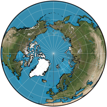
vertical perspective
Parameters: Distance from surface in kms
Classifications
azimuthal
perspective
Graticule
Polar aspect:.
Meridians: Equally spaced straight lines intersecting at the central pole. Angles between them are the true angles.
Parallels: Unequally spaced circles centered at the pole, which is a point. If the usual perspective from above the surface is projected, the spacing of parallels decreases away from the pole, and the equator cannot be shown. If point of perspective is beneath the surface, the spacing may increase or decrease away from the pole, and part of the opposite hemisphere can be shown.
Symmetry: About any meridian.
Equatorial aspect:.
Meridians: Central meridian is a straight line. Other meridians are generally unequally spaced elliptical arcs intersecting at the poles (which may not be visible).
Parallels: Equator is a straight line. Other parallels are usually elliptical arcs. If point of perspective is beneath the surface, the parallels can be elliptical, parabolic, or hyperbolic arcs.
Symmetry: About the central meridian or the equator.
Oblique aspect:.
Meridians: Central meridian is a straight line. Other meridians are generally unequally spaced elliptical arcs intersecting at each pole.
Parallels: One parallel, normally nearer the pole than is the center of projection, depending on the position of the point of perspective, is a straight line. Other parallels are normally elliptical arcs.
Symmetry: About the central meridian.
Range
If point of perspective is above the surface, less than one hemisphere If point of perspective is on the opposite side of the Earth's center, more than one hemisphere.
Limiting forms
Gnomonic projection, if the point of perspective is at the center of the Earth.
Stereographic projection, if the point of perspective is on the surface of the Earth opposite the center of projection.
Orthographic projection, if the point of perspective is at infinity.
In turn, the Vertical Perspective is a limiting form of the Tilted Perspective projection.
Scale
True at the center, if the projection is onto a tangent plane. Scale varies away from the center, depending on the point of perspective.
Distortion
Only the center is free of distortion, if projection is onto a tangent plane. Distortion is severe near the outer limit of the projection, although special locations for the points of projection on the opposite side of the Earth's center result in moderate distortion within a wide range of the center.
Special features
The General Vertical Perspective projection shows the Earth geometrically as it appears from any point above or below the surface when it is projected onto a tangent or secant plane perpendicular to the straight line connecting the point of perspective with the center of the Earth.
Usage
Pictorial views of the Earth, resembling those seen from space.
Specializations
In 1701, Philippe de la Hire of France suggested a point of projection at 1.7071 times the radius. This distance is measured from the center in a direction away from the surface of projection and gives the equator of the polar aspect twice the radius of 45° latitude.
Antoine Parent in 1702, Ernst Hammer about 1890, H.F. Gretschel in 1873, and Hans Maurer in 1935 were among others proposing points of projection for low-error perspectives.
A.R. Clarke and Henry James, in 1862 and later, calculated points of projection (on the far side, below the surface of projection) for minimum-error perspective azimuthal projections of regions, such as continents, bounded by a given great or small circle on the Earth.
The Army Map Service AMS Lunar projection is a far-side perspective selected by Albert L. Nowicki in 1963 to show slightly more than a hemisphere of the Moon, as seen over a period of time from the Earth. The point of projection is 1.53748 times the radius from the center.
See also the Airy nonperspective azimuthal projection.
Origin
Aside from the earlier limiting forms listed below, the perspective projection from a point on the opposite side of the Earth's center was studied in the 18th and 19th centuries as a source of low-distortion projections having geometric construction.
Description adapted from J.P. Snyder and P.M. Voxland, An Album of Map Projections, U.S. Geological Survey Professional Paper 1453. United States Government Printing Office: 1989.