Directory of Map Projections
 Cylindric
- БСАМ
- Карченко-Шабанова
- Урмаева III
- цилиндрическая Павлова
- Braun cylindric
- BSAM
- Cassini
- Cassini-Soldner
- central cylindric
- cylindric equal-area
- Balthasart
- Behrmann equal-area
- Craster rectangular equal-area
- cylindric equal-area
- Gall orthographic
- Gall-Peters
- Hobo-Dyer
- Lambert equal-area cylindric
- Peters
- Smyth equal-surface
- Tobler world in a square
- Trystan Edwards
- equidistant cylindric
- equirectangular
- Gall isographic
- Gall stereographic
- geographic projection
- Karchenko-Shabanova
- la carte parallélogrammatique
- lat⁄lon
- Marinus
- Mercator
- complex latitude plane
- ellipsoidal Mercator
- ellipsoidal oblique Mercator
- ellipsoidal transverse Mercator
- Gauss conformal
- Gauss Hannover
- Gauss-Krüger
- Gauss-Schreiber
- Hotine
- Mercator
- oblique cylindric orthomorphic
- rectified skew orthomorphic
- Thompson transverse Mercator
- transverse cylindric orthomorphic
- Universal Transverse Mercator
- UTM
- Wallis 1 transverse Mercator
- Wallis 2 transverse Mercator
- Web maps Mercator
- Wright
- Miller cylindric
- Patterson
- Pavlov cylindric
- perspective cylindric
- plane chart
- plate carrée
- rectangular
- simple cylindric
- simple perspective cylindric
- transverse plate carrée
- Urmayev III
 Pseudocylindric
- Apian II
- Apianus II
- Atlantis
- Babinet
- Boggs eumorphic
- Bomford modified Gall
- Bromley
- Cabot
- Collignon
- Craster parabolic
- Eckert
- elliptical
- Equal Earth
- equal-area polynomial
- Foucaut
- Fournier II
- Gall-Bomford
- Goode homolosine
- Hölzel
- Hatano asymmetric
- HEALPix
- homalographic
- homolographic
- homolosine
- Hufnagel I
- Hufnagel
- Hufnagel
- Hufnagel II
- Hufnagel III
- Hufnagel IV
- Hufnagel IX
- Hufnagel V
- Hufnagel VII
- Hufnagel X
- Hufnagel XI
- Hufnagel XII
- hyperelliptical
- Kavrayskiy
- loximuthal
- McBryde S3
- McBryde-Thomas
- III
- IV
- McBryde-Thomas flat-pole parabolic
- McBryde-Thomas flat-pole quartic
- McBryde-Thomas flat-pole sinusoidal
- McBryde-Thomas I
- McBryde-Thomas II
- V
- Mercator equal-area
- Mollweide
- Natural Earth
- Nell
- Nell-Hammer
- orthophanic
- Philbrick Sinu-Mollweide
- Putniṇš P4
- Putniṇš
- Putniṇš P1
- Putniṇš P1´
- Putniṇš P2
- Putniṇš P3
- Putniṇš P3´
- Putniṇš P4´
- Putniṇš P5
- Putniṇš P5´
- Putniṇš P6
- Putniṇš P6´
- quartic authalic
- Robinson
- Sanson-Flamsteed
- simple equal-area homotopy
- sinucyli
- sinusoidal
- Snyder minimum-error
- The Times
- Tobler-Mercator
- trapezoidal
- Urmayev
- Wagner
- Winkel
 Conic
Conic- Albers equal-area conic
- Albers-Bonne homotopy
- Albers-Lambert homotopy
- American polyconic
- amulet
- bipolar oblique conic conformal
- Bonne
- Boole
- Bottomley
- Braun stereographic conic
- conical orthomorphic
- dépôt de la guerre
- ellipsoidal Lambert conformal conic
- equal-area pseudoconic
- equidistant conic
- Gauss conformal conic
- globe gores
- Harding
- heart
- Herschel conformal conic
- isoperimetric cordiform
- Lambert conformal conic
- Lambert equal-area conic
- modified Flamsteed
- optimized Albers
- ordinary polyconic
- périgonale equal-area conic
- perspective conic
- polyconic
- Ptolemy
- rectangular polyconic
- shield
- simple conic
- Stab-Werner
- Tissot equal-area conic
- War Office
- Werner
 Azimuthal
- Airy
- azimuthal equidistant
- azimuthal extruded globe
- Berghaus star
- Breusing
- Canters EU
- Chamberlin trimetric
- Close
- doubly azimuthal
- doubly equidistant
- fisheye
- Immler
- isoperimetric pseudoazimuthal
- Lambert azimuthal equal-area
- Lorgna
- McCaw
- Miller oblated stereographic
- orthodromic
- perspective
- AMS lunar
- analemma
- central
- Clarke twilight
- far-side perspective
- Fischer far-side perspective
- gnomic
- gnomonic
- Gretschel
- horologium
- James far-side perspective
- Lowry
- orthographic
- planisphærium
- stereographic
- tilted perspective
- vertical perspective
- Postel
- quasiazimuthal equal-area apple
- quasiazimuthal equal-area polygon
- regular star
- retroazimuthal
- Craig retroazimuthal
- Hammer retroazimuthal back hemisphere
- Hammer retroazimuthal front hemisphere
- Littrow
- Mecca
- Weir azimuthal
- two-point azimuthal
- two-point equidistant
- Wiechel
- zenithal equal-area
- zenithal equidistant
- zenithal equivalent
 Lenticular
- A4
- Aitoff
- Briesemeister
- Dietrich-Hammer homotopy
- Dietrich-Kitada
- Eckert-Greifendorff
- Ginzburg
- Gott equal-area elliptical
- Gott-Mugnolo equal-area elliptical
- Hammer
- Hammer-Aitoff
- hamusoidal
- kiss
- Strebe
- Strebe 1995
- Strebe asymmetric
- Strebe equal-areas
- cartouche
- Strebe-Hammer
- Strebe-Kavrayskiy V
- Strebe-Mollweide
- Strebe-sinusoidal
- Strebe-Snyder flat-pole
- Strebe-Snyder pointed-pole
- Wagner
- Winkel tripel
 Miscellaneous
- ЦНИИГАиК
- ابوریحان بیرونی
- Adams
- Adams hemisphere in a square
- Adams world in a hexagon
- Adams world in a square I
- Adams world in a square II
- Al-Bīrūnī
- Apian globular I
- Apian globular II
- Apianus globular I
- Apianus globular II
- armadillo
- Arrowsmith globular
- August
- August epicycloidal
- Bacon globular
- Cahill conformal butterfly
- Cahill-Concialdi bat
- chaise lounge conformal
- conformal world in an ellipse
- Cox world in a triangle
- Denoyer semi-elliptical
- dymaxion-like conformal
- Eisenlohr
- Fournier globular I
- Gilbert two-world perspective
- Ginzburg VIII
- Glareanus globular
- great circle equal-area tetrahedron
- GS50
- Guyou
- Lagrange
- Larrivée
- lateral equidistant
- Loritz globular
- masque
- Nicolosi globular
- oblated Lagrange
- Ortelius oval
- Peirce quincuncial
- polyhedron conformal face
- pseudorthographic
- quincuncial
- Raisz
- small circle equal-area tetrahedron
- Snyder equal-area tetrahedron
- tri-optimal
- TsNIIGAiK
- van der Grinten
- apple shaped
- van der Grinten
- van der Grinten I
- van der Grinten II
- van der Grinten III
- van der Grinten IV
- van Leeuwen
Snyder minimum-error flat-pole
Classifications
pseudocylindric
equal-area
minimum-error
Graticule
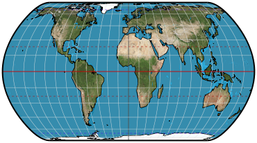
Meridians: Central meridian is a straight line 55% as long as the equator. Other meridians are equally spaced complex curves concave toward the central meridian.
Parallels: Unequally spaced straight parallel lines. Perpendicular to the central meridian.
Poles: Lines 65% the length of the equator.
Symmetry: About the central meridian or the equator.
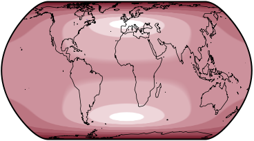
Scale
True along latitudes 46°15´N/S. Constant along any given latitude; same for the latitude of opposite sign.
Distortion
Free of distortion only at latitudes 46°15´N/S at the central meridian. The projection was developed as a minimum-error solution given symmetry, lines for poles in a pseudocylindric projection, and discounting the importance of the polar regions.
Similar projections
The sinucyli is very close across most of the map when weight of sinusoidal = 0.37, weighted axis = Horizontal, φ₁ = 46°15´, and vertical stretch of sinusoidal = 1.0.
Origin
Presented by John P. Snyder in 1985 as part of a broader study in using computers and numerical algorithms to create optimized map projections.
Description ©2010–2020 Mapthematics LLC.