Perhaps someone here has come across this in a book or reference somewhere.
In the former Soviet Union, a lot of the atlases used a map projection not seen elsewhere, which was derived from the Polyconic projection. This is known as the Ginzburg projection.
Lately, in the People's Republic of China, a different, but closely related, projection is used almost always for maps of the world. It is called the Latitudinally Equal Differential Polyconic Projection. Older world maps from there may have tended to use the Winkel Tripel.
This made me wonder if the DPRK had a favorite map projection as well. However, I've seen no images on the web of any North Korean atlases... the only thing I did find was an image of a metal sculpture of a world map on an interior wall of a building. The appearance of that sculpture suggests it was inspired by the Winkel Tripel.
Does North Korea have a favorite world map projection?
-
quadibloc
- Posts: 338
- Joined: Sun Aug 18, 2019 12:28 am
-
daan
- Site Admin
- Posts: 1022
- Joined: Sat Mar 28, 2009 11:17 pm
Re: Does North Korea have a favorite world map projection?
There are a lot of Ginzburg projections, and many of them are being, or have been, used in the Soviet Union and Russia, especially in atlases. (Geocart implements six.)
Apologies for the name “latitudinally equal-differential polyconic projection”. I didn’t know what else to call it, and that’s pretty much a direct translation. Nobody seems to know the origin and math for the projection; modern versions are apparently reconstructions of what showed up in the early 60s in China.
If you learn anything about the DPRK’s atlases, please let us know! They’re probably state secrets, though.
Cheers,
— daan
-
quadibloc
- Posts: 338
- Joined: Sun Aug 18, 2019 12:28 am
Re: Does North Korea have a favorite world map projection?
Although I'll admit that's something I would tend to suspect myself, I recently learned something that leads me to suspect that this is not quite the case.
In Japan, there is a community of people of Korean descent. News articles have noted that although they're descendants of people Japan kidnapped during or before World War II, they are classed as resident aliens, making them unable to get passports, and leading to them being required to be fingerprinted annually. I recently learned that many of their children attend private schools to keep their ties to the Korean language and culture alive. Those schools, however, are run by North Korea!
So apparently at least some North Korean atlases aren't state secrets.
EDIT: Although I thought I tried the Internet Archive in my first attempt, I see that I didn't quite do it right. This time, I turned up an entry with a trove of North Korean textbooks. Apparently someone on a trip to Korea snagged them off someone's computer.
Included was a textbook on "cartology", but that turned out to be drafting/mechanical drawing, not cartography. There were also three geography textbooks. Only one of them included any world maps - on one page, two weather maps.
https://archive.org/stream/DPRKTexts/Ed ... 5/mode/2up
John Savard
-
daan
- Site Admin
- Posts: 1022
- Joined: Sat Mar 28, 2009 11:17 pm
Re: Does North Korea have a favorite world map projection?
(I lived six years in Japan, so the matter of the Korean communities is something I ran into directly a few times and indirectly rather frequently.)
The Korean-language schools of the Chongryon faction (North Korean sympathizers) have, historically, had some funding from North Korea, but there is no direct involvement from the North Korean government and certainly no substantial educational materials shipped over. I don’t think we can conclude anything about North Korean atlases from that angle.
I am not even sure North Korea produces atlases. The needs of government could be met by imports indirectly from South Korea, and I get the impression that teaching the populace about the rest of the world is not an urgent concern of the government.
— daan
-
quadibloc
- Posts: 338
- Joined: Sun Aug 18, 2019 12:28 am
Re: Does North Korea have a favorite world map projection?
I can set your mind at rest on that score. My web searching turned up a few images - but not one of the map of the world - from a recent atlas of the world from North Korea's "Scientific Encyclopedia Publishing House". The reason for them appearing in news stories was because this atlas showed the Crimea as part of Russia now - and the Russian Embassy in North Korea was so tickled pink by this, it put it on its Facebook page.
EDIT: Further web searching finds that the publisher in question is usually referred to in English as the "Science and Encyclopedia Publishing House", as it is named in numerous news items not connected with the recent appearance of Crimea in one of their atlases.
Last edited by quadibloc on Tue Dec 10, 2019 9:19 pm, edited 1 time in total.
-
daan
- Site Admin
- Posts: 1022
- Joined: Sat Mar 28, 2009 11:17 pm
Re: Does North Korea have a favorite world map projection?
Ah! Nice find. The weather maps would be on the latitudinally equal-differential polyconic projection.quadibloc wrote: ↑Tue Dec 10, 2019 7:30 pm EDIT: Although I thought I tried the Internet Archive in my first attempt, I see that I didn't quite do it right. This time, I turned up an entry with a trove of North Korean textbooks. Apparently someone on a trip to Korea snagged them off someone's computer.
Included was a textbook on "cartology", but that turned out to be drafting/mechanical drawing, not cartography. There were also three geography textbooks. Only one of them included any world maps - on one page, two weather maps.
https://archive.org/stream/DPRKTexts/Ed ... 5/mode/2up
— daan
-
quadibloc
- Posts: 338
- Joined: Sun Aug 18, 2019 12:28 am
Re: Does North Korea have a favorite world map projection?
The one I remember seeing frequently in Soviet atlases was the Ginzburg VI.
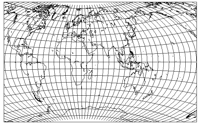
As for the Latitudinally Equal Differential Polyconic Projection, I finally got around to pointing out its embarassing little secret on my web page:
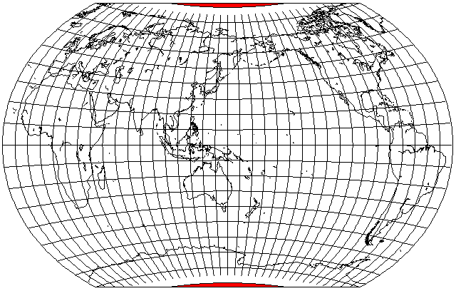
It shows areas beyond the pole lines on the map as though they're still part of the globe.
Also, incidentally, in searching for images related to Korea and Atlases, I found a news item from South Korea concerning their pleasure that a major atlas from France had finally shown what is usually called the Sea of Japan as also being called the East Sea.