On distortion and optimal projections

General discussion of map projections.
Post Reply
Atarimaster
Posts: 446
Joined: Fri Nov 07, 2014 2:43 am

Re: On distortion and optimal projections

Post by Atarimaster »

quadibloc wrote:Years ago, at the Map Collection at the University of Alberta, I saw an old German book with quite a few maps on an unusual-looking projection I had not seen before (…) and I suspect that it is very likely that the book I saw was actually the one by Bruno Dietrich that you mention.
Did the maps in the book you saw look like this?
If so, then yes, it was Dietrich’s book.
kitada-1.jpg
kitada-1.jpg (147.93 KiB) Viewed 5483 times
kitada-2.jpg
kitada-2.jpg (118.85 KiB) Viewed 5483 times

… and by the way (I can’t remember if I ever posted this little bit of information):
The book’s preface mentions a student called K.H. Wagner who drew the maps. Wonder who that might be? ;)
quadibloc
Posts: 292
Joined: Sun Aug 18, 2019 12:28 am

Re: On distortion and optimal projections

Post by quadibloc »

Atarimaster wrote:Did the maps in the book you saw look like this?
If so, then yes, it was Dietrich’s book.
Thank you! Yes, they did, and so it was.

And I did not know the interesting bit of trivia that the student who drew the maps was Karlheinz Wagner of the Wagner IV projection. (From Wikipedia, I later learned that his formal name was Karl Heinrich Wagner; apparently Karlheinz is a kind of German nickname for Karl Heinrich.)

John Savard
Last edited by quadibloc on Sun Aug 18, 2019 10:08 pm, edited 1 time in total.
daan
Site Admin
Posts: 977
Joined: Sat Mar 28, 2009 11:17 pm

Re: On distortion and optimal projections

Post by daan »

quadibloc wrote:Years ago, at the Map Collection at the University of Alberta, I saw an old German book with quite a few maps on an unusual-looking projection I had not seen before. I couldn't find out any more information about that projection, though. Many years later, I learned about the Van der Grinten IV projection, and I assumed that's what the book must have used.

Just by chance - I think I was doing a web search for information on Bartholomew's Regional Projection - I came across this forum post, and I suspect that it is very likely that the book I saw was actually the one by Bruno Dietrich that you mention. I have my own personal web page which talks about map projections, and it's illustrated mostly with drawings of maps that I generated using a little BASIC program I wrote myself.

Well, starting from your post, I retraced Kozo Kitada's steps, and implemented the projection in my little BASIC program. Noting that there is one point of similarity between it and the Mollweide (the ratio between the sinusoid and the circle determines the Mollweide's vertical stretch on the equator, and this projection's stretch on the Prime Meridian) I even plotted a transverse aspect of it.
Glad you finally resolved that little mystery.

Did you track down Kitada’s paper or did you derive the formulæ yourself?

Welcome to the forums!

Best,
— daan
quadibloc
Posts: 292
Joined: Sun Aug 18, 2019 12:28 am

Re: On distortion and optimal projections

Post by quadibloc »

daan wrote:Did you track down Kitada’s paper or did you derive the formulæ yourself?
The latter; your forum post gave me almost all the information I needed. Example images of that projection, drawn I presume with Geocart, on the Web, helped me too, as from them I confirmed a hunch that the basic shape of an infinitesimal crescent lune in any position is like a paraboloid or a sinusoid - so the meridians are all divided uniformly for latitude.

My web page discusses the formulae for the positions of the meridian arcs; that, of course, only required simple geometry and algebra.

And now I have another mystery to clear up. I had seen somewhere a clip from a James Bond movie - it was probably either Tomorrow Never Dies or The World is Not Enough. There was a computer screen of some kind with a map of the world (white outline on a black background) and the projection was also "apple-shaped". I don't think it was a Lagrange or an August. So was that a Van der Grinten IV or a Dietrich-Kitada?
quadibloc
Posts: 292
Joined: Sun Aug 18, 2019 12:28 am

Re: On distortion and optimal projections

Post by quadibloc »

daan wrote:I have my ideas, but nobody knows. I can give you a hint about what the optimal equal-area map of the whole world, split along one meridian, might look like, though. The next map is on what I call the “Dietrich–Kitada” projection. Bruno Dietrich was the author of a 1927 German text, Grundzüge der allgemeinen Wirtschaftsgeographie. The curious thing about this text is that it is illustrated with many full-page thematic maps, all in a single map projection, one whose construction method is… unknown, as far as I know. In late 1957, in a paper titled 世界全図に適する新図法の提出まで(続) (“Presenting new map projections for whole-world maps (continued)”), a Japanese mathematical cartographer named Kōzō Kitada (北田 宏蔵) described the projection he found in this German text, ascertained that it was equal-area, or at least nearly so, and set about formulating a recreation of it. He set the meridians to circular arcs, bounded the front hemisphere by a full circle, and determined the parallel shapes required to preserve area with these constraints. This is what he came up with:
Dietrich-Kitada.jpg
The true optimal map will look somewhat different than this, but this is the gist.
This statement of yours just may have proven prophetic.

After learning about the Dietrich-Kitada projection from this post, I implemented it in my crude BASIC-language map-drawing program, and played around with drawing it in a few different aspects. I only managed to find one, centered near Moscow, that made a tolerable world map; the Dietrich-Kitada has a large area of low error, but also a large area of high error, and its distribution of error seems perverse.

One of the maps I drew was in a transverse aspect - specifically because there were some similarities to the Dietrich-Kitada and the Mollweide (or should that be the transverse Mollweide). The shape of the meridians suggested to me that an interesting projection might be obtained by subjecting the Dietrich-Kitada projection to the same process used by Gott with the Mollweide.

Here is the projection that resulted:
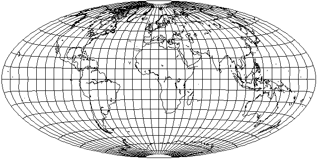
Image

The world is placed on a 2:1 ellipse, as with the Mollweide and the Hammer. But the central portion of the projection... looks almost like an equal-area cylindrical. In conventional aspect, it's not all that great, but as it has a large low-distortion area around the Equator, it may be easier to find a useful aspect for this projection than it was for the original Dietrich-Kitada.

And indeed it was:
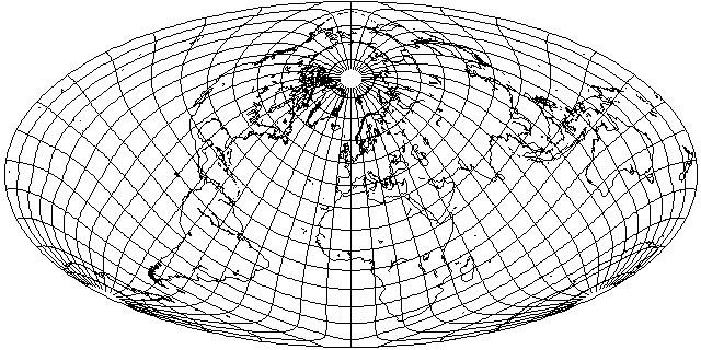
Image

Using the same aspect as Bartholomew's Nordic... I get a surprisingly good-looking Australia and New Zealand, thanks to its cylindrical-like nature near the Equator.

Oh, and as the scale is uniform along the Equator, this projection can even be interrupted. That could provide interesting possibilities - and, of course, it could be squashed, like the Bromley-Mollweide, to get rid of the Equatorial stretch if desired.

Having tried a few other orientations with this projection, though, even though it clearly differs from the Mollweide, it doesn't seem that the differences are great enough to yield any benefits that would justify all the extra calculation.

All this inspired me to do something involving less fancy calculation; to go back to the Mollweide, and come up with this interrupted oblique Mollweide which keeps Eurasia in one piece - and Antarctica - and, as much as possible, the South Pacific islands as well!
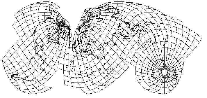
Image

In the event this projection generates any interest, I added an explanatory image describing it.
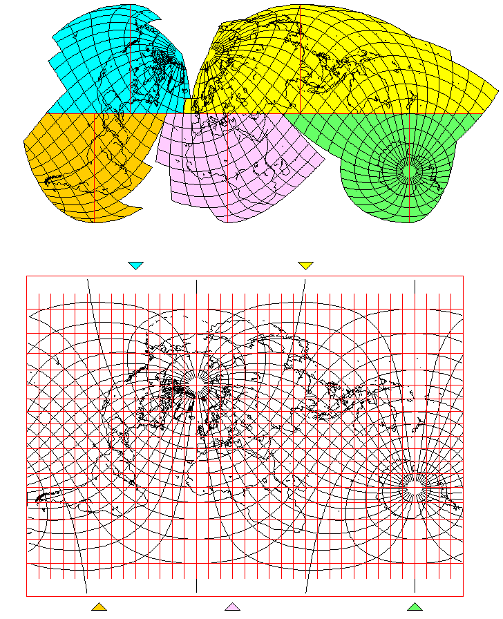
Image
Last edited by quadibloc on Mon Apr 20, 2020 9:52 pm, edited 1 time in total.
daan
Site Admin
Posts: 977
Joined: Sat Mar 28, 2009 11:17 pm

Re: On distortion and optimal projections

Post by daan »

quadibloc wrote:It doesn't seem that the differences are great enough to yield any benefits that would justify all the extra calculation.
Calculation is cheap these days. Not a concern for me, although I suppose the programming could discourage someone.

More concerning is the bit of kinkiness. Still, you did manage to dig a shapely Australia and New Zealand out of that, considering.

That’s a handsome and evocative interruption scheme you applied to the Mollweide. I sort of think it’s the explanation for the explanatory map below it.

— daan
quadibloc
Posts: 292
Joined: Sun Aug 18, 2019 12:28 am

Re: On distortion and optimal projections

Post by quadibloc »

daan wrote:Calculation is cheap these days. Not a concern for me, although I suppose the programming could discourage someone.
That's true. But even something that's cheap isn't worthwhile if there are no benefits. It seems like my projection may offer some advantages the Mollweide doesn't, but it's not clear to me if that is the case.
daan wrote:More concerning is the bit of kinkiness.
Yes, that is unattractive. But it's a natural consequence of the mathematics of the projection, not due to an error as in the Adams' conformal projection of the world on an ellipse. As that's only at the edges of the projection, it goes away in an interrupted version (yes, it can be interrupted despite the curved parallels):
Image
daan wrote:That’s a handsome and evocative interruption scheme you applied to the Mollweide. I sort of think it’s the explanation for the explanatory map below it.
Thank you. The explanatory map is to make things easier for anyone else who would like to draw one on their own, by showing where the standard parallels are. If Athelstan Spilhaus can make maps of the whole world ocean, which covers 3/4 of the planet, then it's high time someone came up with an interrupted projection that does it all for the landmasses: Asia is uninterrupted, Antarctica is uninterrupted and looks decent, and even the South Pacific islands aren't cut badly (Hawai'i and Easter Island are separate from the others, being joined to the Western Hemisphere instead of the Eastern, but that's unavoidable in a projection not centered on the Pacific.)
Atarimaster
Posts: 446
Joined: Fri Nov 07, 2014 2:43 am

Re: On distortion and optimal projections

Post by Atarimaster »

quadibloc wrote:Hawai'i and Easter Island are separate from the others, being joined to the Western Hemisphere instead of the Eastern
… so they end up on the same lobe as the countries they belong to politcally. I think that’s an advantage rather than a shortcoming.
quadibloc
Posts: 292
Joined: Sun Aug 18, 2019 12:28 am

Re: On distortion and optimal projections

Post by quadibloc »

Atarimaster wrote:I think that’s an advantage rather than a shortcoming.
It is the right choice, if a split has to be placed somewhere. The Pacific could be in the middle of the map, but splitting Iceland from Europe is worse.
daan
Site Admin
Posts: 977
Joined: Sat Mar 28, 2009 11:17 pm

Re: On distortion and optimal projections

Post by daan »

Still quite crude, but I have worked out the differential process to realize my conjecture about the optimal equal-area map. It has been 25 years since I formulated the conjecture, and I have been thinking ever since about how to demonstrate it. I wish I were smarter.

Here it is as applied to a world map interrupted along the 180th meridian.
With graticule
With graticule
optimal equal-area distortion graticule.jpg (174.43 KiB) Viewed 5383 times
Without graticule
Without graticule
optimal equal-area distortion.jpg (129.19 KiB) Viewed 5383 times
Compare this against Dietrich-Kitada, which I noted as being close to the optimal, and against Eisenlohr, which is the optimal conformal map. This equal-area thing has the same isocols as the Eisenlohr. Maximum angular deformation is about 80°, and is constant along the boundary. Dietrich-Kitada’s maximum is about 88°.

Everything that looks weird is an artifact of the crude implementation, including the goofy red oval toward the center.

Cheers.
— daan
Post Reply