Aitoff in Polar Coordinates

General discussion of map projections.
quadibloc
Posts: 292
Joined: Sun Aug 18, 2019 12:28 am

Aitoff in Polar Coordinates

Post by quadibloc »

I'm fond of the Sinusoidal projection and Bonne's projection because they combine the popular property of being equal-area with uniform scale along some axes.

But I've encountered frustration in using those projections in an interrupted form to make a pleasing map of the world, as opportunities to interrupt them don't seem to come at the right places. So I went looking for more flexibility. For all I know, the projection I devised in this search, and deemed a failure, may have been invented by someone else before.

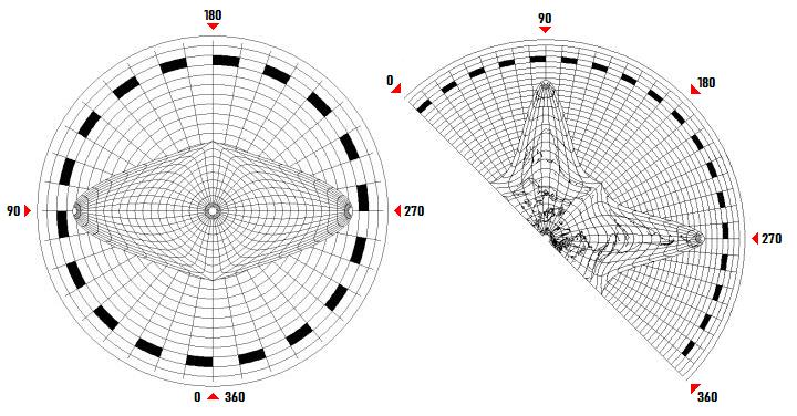
Start with a transverse Sinusoidal, with a pole at the center:

Image

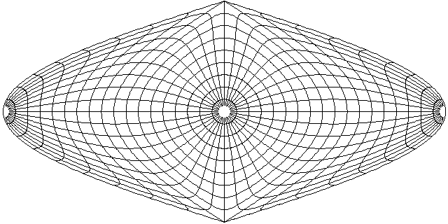
Apply Aitoff's principle to it, but in polar coordinates - and in reverse; stretch first, then squeeze. Here's what I got:

Image

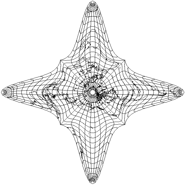
I felt the angular distortion, being much worse than I expected, was too severe to allow this projection to be useful for its intended purpose.

However, it might be that the area near the central pole might still be useful as a tiny piece permitting bits of an interrupted Bonne's or Sinusoidal to be attached together at a different angle.
Last edited by quadibloc on Mon Apr 20, 2020 10:13 pm, edited 1 time in total.
daan
Site Admin
Posts: 977
Joined: Sat Mar 28, 2009 11:17 pm

Re: Aitoff in Polar Coordinates

Post by daan »

That’s wild.

I didn’t quite grasp how you applied Aitoff’s principle. You said “in polar coordinates”. Does this mean the scaling is radial? …how would that work?

— daan
quadibloc
Posts: 292
Joined: Sun Aug 18, 2019 12:28 am

Re: Aitoff in Polar Coordinates

Post by quadibloc »

daan wrote:I didn’t quite grasp how you applied Aitoff’s principle. You said “in polar coordinates”. Does this mean the scaling is radial? …how would that work?
Yes, the scaling is radial. So look at the Sinusoidal in the first image, with a pole in the center. Imagine that, on that map, I stretched out longitude, so that ten degrees of longitude on the map only represented five degrees of longitude on the globe.

And then to make up for that, to scale longitude properly again, I take the piece of paper the map is drawn on, and squeeze it by taking angles around the origin, cutting them in half. So the Sinusoidal map that only contained a hemisphere is bent into an L-shape... with a second one, having the other hemisphere in it, completing the world and the star.

I hope my explanation is comprehensible. The East and West sides of the Sinusoidal correspond to all four cardinal points - and the diagonal points correspond to the North and South poles (referring to the places on the Sinusoidal in conventional aspect terms).

I'm not really a fan of unusual and "wild" map projections, so I was disappointed that this turned out with a fairly high value of distortion. But it was still kind of cute, and may potentially have some uses.
daan
Site Admin
Posts: 977
Joined: Sat Mar 28, 2009 11:17 pm

Re: Aitoff in Polar Coordinates

Post by daan »

quadibloc wrote:
daan wrote:I didn’t quite grasp how you applied Aitoff’s principle. You said “in polar coordinates”. Does this mean the scaling is radial? …how would that work?
Yes, the scaling is radial. So look at the Sinusoidal in the first image, with a pole in the center. Imagine that, on that map, I stretched out longitude, so that ten degrees of longitude on the map only represented five degrees of longitude on the globe.

And then to make up for that, to scale longitude properly again, I take the piece of paper the map is drawn on, and squeeze it by taking angles around the origin, cutting them in half. So the Sinusoidal map that only contained a hemisphere is bent into an L-shape... with a second one, having the other hemisphere in it, completing the world and the star.

I hope my explanation is comprehensible. The East and West sides of the Sinusoidal correspond to all four cardinal points - and the diagonal points correspond to the North and South poles (referring to the places on the Sinusoidal in conventional aspect terms).

I'm not really a fan of unusual and "wild" map projections, so I was disappointed that this turned out with a fairly high value of distortion. But it was still kind of cute, and may potentially have some uses.
Explanation is good. Thanks.

The technique bears some relation to my “radial oozing” technique described in A bevy of area-preserving transforms for map projection designers, but is distinct in how it achieves the “oozing” by using a constant angular compression rather than variable, and relying on the meridional duplication of Aitoff to compensate. The radial nature of it does greatly constrain the space, and therefore the flexibility, unfortunately. But perhaps with more thought it could be put to better use.

— daan
quadibloc
Posts: 292
Joined: Sun Aug 18, 2019 12:28 am

Re: Aitoff in Polar Coordinates

Post by quadibloc »

I'm glad my verbal explanation was clear. But I went ahead in the meantime, and created a diagram to make it clear to the people who visit my web site:

Image

and I'm not sorry I did, on the basis that if even you have a little trouble, ordinary visitors to my site will need all the help they can get.
Last edited by quadibloc on Mon Apr 20, 2020 10:14 pm, edited 1 time in total.
daan
Site Admin
Posts: 977
Joined: Sat Mar 28, 2009 11:17 pm

Re: Aitoff in Polar Coordinates

Post by daan »

quadibloc wrote:If even you have a little trouble, ordinary visitors to my site will need all the help they can get.
Heh heh. Better to get it from the horse’s mouth than to jump to conclusions. Diagram makes it even more obvious.

— daan
quadibloc
Posts: 292
Joined: Sun Aug 18, 2019 12:28 am

Re: Aitoff in Polar Coordinates

Post by quadibloc »

In any case, this has helped clarify my thinking.

What I really want to do is something to which this particular new projection is not relevant.

I basically want to take this interrupted Bonne's projection,

Image

and keep the standard parallel for Eurasia at 50 degrees North, where it makes the continent look reasonably nice, and yet take the interruption between Africa and Australia, and move it down to 20 degrees North so that it doesn't cut into Eurasia.

It's simple enough to do that. Just continue Bonne's projection without the interruption down to 20 degrees North. Then, to avoid a kink, instead of switching directly to the two standard meridians I'm using below 50 degrees North now, fudge things a little, so that there's a cusp where the two lobes separate, and only move to using normal standard meridians a bit further south. In your paper, you refer to this technique as "directional path offset", and once I've bit the bullet of getting the math right, I'll be able to join a Bonne's projection to another one at the "wrong" latitude without kinks.

Directional path offset might also help me, if I can't gracefully switch to a more southerly standard parallel for the Americas, to switch from the standard meridian needed for North America to one more suitable to South America in that same map.

And the result will be an interrupted equal-area projection that fully meets my goals of low angular distortion.
Last edited by quadibloc on Mon Apr 20, 2020 10:14 pm, edited 1 time in total.
daan
Site Admin
Posts: 977
Joined: Sat Mar 28, 2009 11:17 pm

Re: Aitoff in Polar Coordinates

Post by daan »

Ah, I see what you’re getting at.

Directional path offset will certainly work to close up the excess interruption. It will heavily impact Australia, though, and so you may find yourself choosing a different central meridian for that lobe, or you may find that the effects there are too distasteful to be overcome.

You could use a radial version of that, which would reduce the shearing in Australia: With the north pole as the center, starting at the parallel of the cusp, and working southward from there, slide each parallel (and every parallel beyond with it) enough to close the gap, and then do the same with the (infinitesimally next) parallel, which itself has already been shifted some from the previous parallel, &c. This would, again, distort Australia, but I think changing the central meridian would fix the problem much better than it would using lateral offsetting.

This will also give you a better train of distortion for South America, if you choose to use it that way. No cusp that you care about to close up, but same idea.

— daan
quadibloc
Posts: 292
Joined: Sun Aug 18, 2019 12:28 am

Re: Aitoff in Polar Coordinates

Post by quadibloc »

It turns out I can use a more southerly standard parallel for the Western half of the map, so South America is not an issue.

If I don't worry about having a kink in the map, which is reasonable at least for this preliminary sketch, here is the kind of map I'm thinking of:

Image

I was intending to use directional path offset only in the strip starting at the kink and extending 10 degrees to the south, so Australia wouldn't be impacted, it would only be rotated slightly from what you see in this map. So perhaps I'm not quite understanding what directional path offset means.

I would displace the lobe with Australia along the parallels in that strip. At the beginning, the displacement would increase by an amount needed to cancel the kink; at the end, the displacement would be constant, not to introduce a new one. The easiest scheme for assigning the displacements would be according to a parabola in a Cartesian coordinate space where r and theta, from the center point of the parallels, are the coordinates. How best to put that in my map drawing program as a general capability, not hard-coded for one map, is what takes me some time to think about.
Last edited by quadibloc on Mon Apr 20, 2020 10:15 pm, edited 1 time in total.
daan
Site Admin
Posts: 977
Joined: Sat Mar 28, 2009 11:17 pm

Re: Aitoff in Polar Coordinates

Post by daan »

The methods I proposed avoid visual kinking throughout most of the map. The second derivatives would be discontinuous, and that would show up clearly in distortion diagrams. Where kinking happens would be is along the sewn-up seam, but in this case, the seam is so short and the distance moved is so short that the kinking shouldn’t be blatant.

The reason these methods affect Australia is that the sliding has to be applied to the entire map outward from wherever you start it. You’d want the direction that you slide from to be normal to the interruption so that you don’t get kinking. However, your interruption is curved, whereas your sliding direction is constant, and therefore you can’t avoid a little kinking except at one point.

— daan
Post Reply